China's claim on the South China Sea: How many dashes make a line?

China's recent release of a new "standard" map of the South China Sea by the Ministry of Natural Resources has provoked some negative reactions from China's neighbours. The map, which was released on 28 August, included a dashed line encircling large parts of the South China Sea. The inclusion of a dash east of Taiwan has triggered questions about whether this map represented a change in China's territorial claims. The answer is simple: no.
A chequered history
The history of China's claim to the South China Sea is chequered, and at times beset by happenstance and incompetence. China first published a map containing a "U-shaped line" around the South China Sea in February 1948 as part of its "Atlas of Administrative Areas of the Republic of China".
Work by Dr Chris Chung of the University of Toronto in the archives of the Republic of China (ROC) has demonstrated that the government committee that drew the line intended it to be a schematic indication of the ROC's claims to islands in the South China Sea. A meeting held in the ROC Ministry of the Interior on 25 September 1946 agreed on a sketch map in order to "delimit the scope of what is to be received for the purpose of receiving each of the islands in the South China Sea".
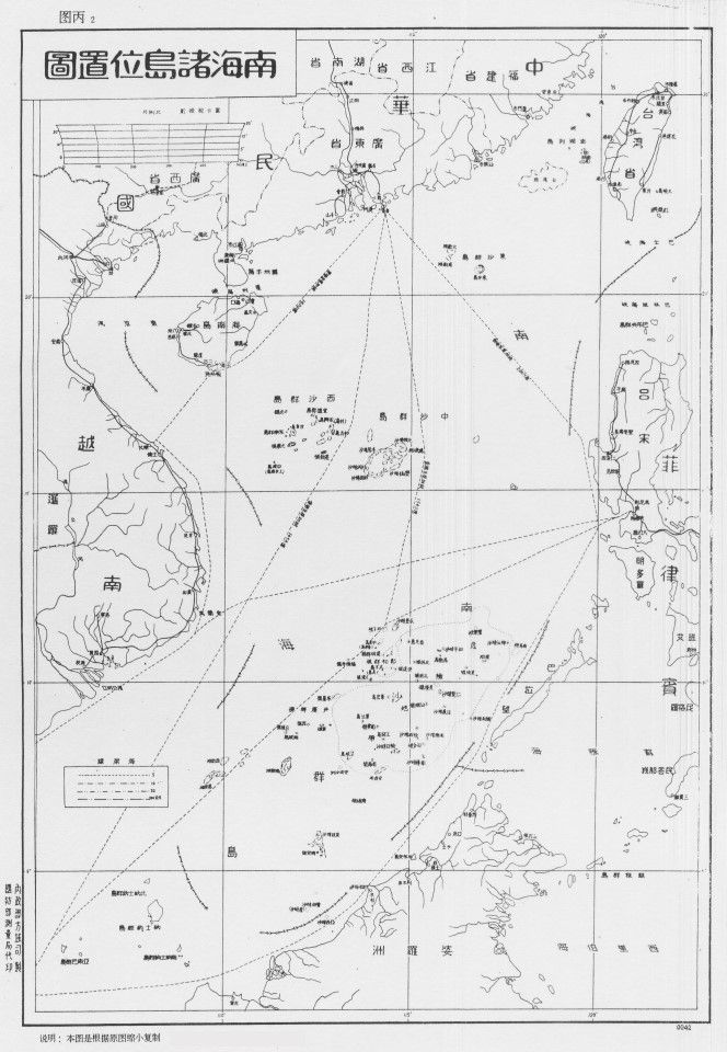
This "Location Sketch Map of the South China Sea Islands" (nanhai zhudao weizhi lüetu, 南海诸岛位置略图) contained eight dashes running around the sea, ending with one that separated the Philippines from Taiwan. At the time when these maps were being drawn, the ROC was the recognised government of both mainland China and Taiwan.
After the Second World War, there had been lengthy discussions among Chinese officials about the exact extent of China's territorial claims. No Chinese government had ever claimed the Spratly Islands before this time. Then, some officials believed that the newly independent Philippines or French Indochina or the British authorities in Borneo would have a stronger claim.
The arguments were not resolved until 14 April 1947, when the Ministry of the Interior convened a meeting with representatives from the Ministry of National Defence, the Ministry of Foreign Affairs, and the Navy Command Headquarters. According to research by academics Tsung-Han Tai and Chi-Ting Tsai, it was this meeting that officially decided that the southernmost point of the Chinese claim should be a feature by the name of James Shoal.
The map that the committee finally published in 1948 contained 11 dashes, with two of them separating Taiwan from the Philippines.
However, even this claim was not clear-cut. When the Ministry of Information of the ROC published a new edition of its "Handbook" later in 1947, it noted the following on page 1: "The southernmost ... boundaries remain to be settled ... and the sovereignty of the Tuansha Islands on the south are contested among China, the Commonwealth of Philippines and Indochina."
It is worth noting that the official Chinese name for the Spratly Islands at this time was "Tuansha", not Nansha. Tuansha - literally "chaotic sands" - seems to have been a translation of the term "dangerous ground", which appeared on English-language maps of the time. The Chinese name for James Shoal is "Zengmu Ansha", a transliteration of the English name using the letters "J" and "M".
Different maps, similar claims
The committee's map seems to have been based on the work of a self-taught geography professor called Bai Meichu who drew a (solid) U-shaped line around the South China Sea in his "New Atlas of China's Construction" (zhonghua jianshe xintu, 中华建设新图) in 1936. Unfortunately, Bai's map was full of mistakes. He seems to have copied a British atlas and misinterpreted its markings.
As a result, Bai's line - and China's modern-day claims - were drawn around three non-existent islands: Vanguard Bank off southeastern Vietnam, James Shoal off Brunei and Seahorse Shoal off the Philippines. All of them were underwater features. Interestingly, Bai's 1936 line did not include Taiwan because, at the time, the island was a colony of Japan.
Two of Bai's students went on to become two key members of the ROC's map-making committee. Intriguingly, Fu Jiaojin (傅角今) and Zheng Ziyue (郑资约) appear to have taken Bai's misunderstandings into government and China's official claims in the South China Sea. The map that the committee finally published in 1948 contained 11 dashes, with two of them separating Taiwan from the Philippines.
The line remained on Chinese maps, but the precise locations of the dashes were never specified, and their meaning was never publicly explained.
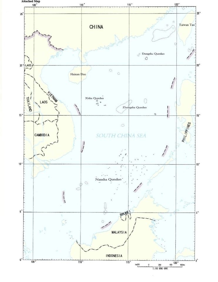
After their victory in the Chinese Civil War, the new Communist government came to an agreement with their comrades in the Vietnamese communist movement and issued a new map. This map, issued in the early 1950s (even before France agreed to withdraw from Indochina) omitted two dashes drawn through the Tonkin/ Beibu Gulf. The U-shaped line now had nine dashes. Notably, however, it still encompassed the Paracel and Spratly Islands and Taiwan.
The line remained on Chinese maps, but the precise locations of the dashes were never specified, and their meaning was never publicly explained. However, in 2009, the Chinese mission to the United Nations published a slightly different map of the South China Sea, again with nine dashes but in slightly different places. Just one was located between the Philippines and Taiwan.
Then, in 2013, a new - vertical - map projection of Chinese territory was published by Sinomap, the Chinese state mapping authority. This was reproduced by the Hunan Map Publishing House the following year. This map showed an apparently "new" dash, a tenth, east of Taiwan. The Philippines government protested, although this was not a new claim, it was just a new way of showing the old claim.
In reality, the line outlining China's claims has not changed significantly since 1948 and its basis remains just as nonsensical as it did back then.
This article was first published in Fulcrum, ISEAS - Yusof Ishak Institute's blogsite.
Related: How the nine-dash line undermines China's economic interests in Vietnam | South China Sea dispute: Why can't Southeast Asian countries stand united against China's claims? | The South China Sea: More dangerous and unstable | SEA states have few options to mitigate escalating South China Sea tensions | Indonesia crosses swords with China over South China Sea: 'Bombshell to stop China's expansionism'? | China's 'hegemony with Chinese characteristics' in the South China Sea